Camping On Northern Vancouver Island
The northern zone of Vancouver Island has the most remote campgrounds on the whole island. A lot of them are free and not maintained so please leave them as you found them and haul out any garbage you see or bring in.
Not as populated as the central and southern zones of the island, helps define its remoteness. As of 2023 Stats BC estimates the population for the north island to be close to 52k.
The north island region is represented by two Regional Districts. They are Mount Waddington Regional District and Strathcona Regional District.
The largest towns are Alert Bay, Port Alice, Port Hardy, Port McNeil, Sayward, Tahsis and Zeballos.
First Nations Of The Northern Island

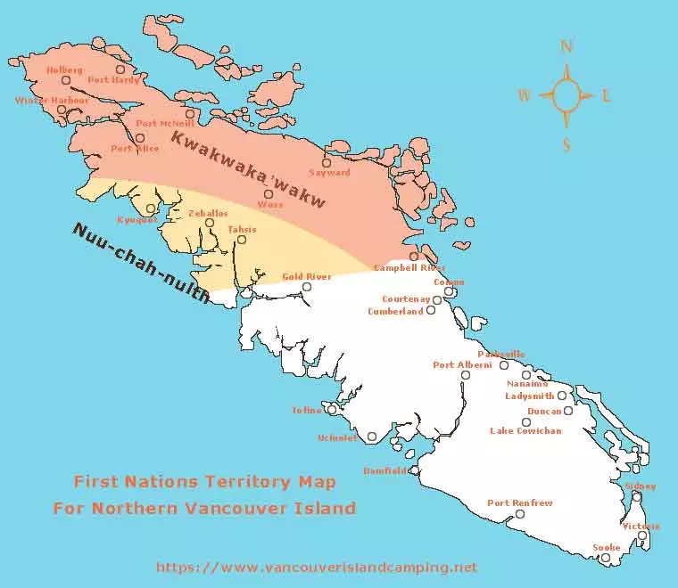
The north island is the traditional territory of the Kwakwa̱ka̱ʼwakw speaking First Nations. They are comprised of the following individual peoples:
- A̱ʼwa̱ʼetła̱la
- Da̱ʼnaxdaʼx̱w
- Ehattesaht
- Gwaʼsa̱la
- Gwat̕sinux̱w
- Gwawa̱ʼenux̱w
- Kwaguʼł
- Ḵwiḵwa̱sut̓inux̱w
- Kyuquot/Cheklesahht
- Ławitsis
- Mamaliliḵa̱la
- Maʼa̱mtagila
- ʼNak̕waxdaʼx̱w
- ʼNa̱mg̱is
- Nuchatlaht
- Quatsino
- T̓łat̕ła̱siḵwa̱la
- Wiwēkam – actual location is Campbell River in Central Vancouver Island
- Wiwēqay̓i – actual location is Cape Mudge in Central Vancouver Island
A few territories overlap in the northern region of Vancouver Island. The Nuu-chah-nulth speaking First Nations covers the south western portion of the northern region of Vancouver Island. Some of the Kwakwa̱ka̱ʼwakw speaking First Nations also reside in and around Campbell River.
If any of this information regarding First Nations is inaccurate please let us know so we can make it right. We did our best to do our due diligence when researching the content and it isn’t our intention to offend or insult any First Nation peoples.
Map Of Campgrounds On Northern Vancouver Island
I have done my best to place all the campgrounds on the map below to the best of my knowledge. It is an ongoing adventure to get to them all but I will eventually. The boundary starts at Sayward and runs across to Yuquot on the west coast and up to the northern tip of the island.
